
6/1/06
Table of Contents
List of Exhibits ... . ii
List of Acronyms ... .. iv
Tab One
Background... ... 1
What is the Expert Review Panel’s mission? ... ...1
What are the questions for the Expert Review Panel related to the Viaduct and SR
520 projects? ... ..2
Who are the Expert Review Panel members? ... ...6
Where are these projects located? ... .10
Viaduct Project ... . 12
Where is the Viaduct Project located? ... ...12
Why is replacing the Alaskan Way Viaduct and Seawall so important? ... ..14
What is the history of the Viaduct Project? ... .16
What is the purpose and need statement for the project? ... .17
What replacement alternatives are being considered? ... ...17
What is the Viaduct Project’s schedule? ... ...21
Who are the Viaduct Project partners? ... ..21
SR 520 Project ... .. 22
Where is the SR 520 Project located? ... .22
Why is replacing SR 520 so important? ... ...22
What is the history of the SR 520 Project? ... ..25
What is the purpose and need statement for the project? ... .27
What replacement alternatives are being considered? ... ...27
What is the SR 520 Project’s schedule? ... ...30
Who are the SR 520 Project partners? ... ...30
Cost, Funding, and Management ... .. 31
How is transportation funded in Washington? ... ..31
How much will the Viaduct and SR 520 projects cost? ... ...33
What laws and regulations apply to these projects? ... ...37
What other regional transportation projects, programs, or funding initiatives might
affect these projects? ... ...38
How does WSDOT develop costs estimates and schedules? ... .41
How does WSDOT plan to manage these projects? ... ...47
Who are the project teams and how are they organized? ... .55
Table of Contents June 2006
Expert Review Panel Notebook Page i
Additional Information ... . 59
What is the state of transportation in Washington? ... ..59
What agencies and governance structures oversee transportation services? ... ..64
Table of Contents June 2006
Expert Review Panel Notebook Page ii
Exhibits
Tab One
1-1 1-2 ..……... 1-3 1-4 1-5 1-6 1-7 1-8 1-9 ..……………... 1-10 1-11 1-12 1-13 1-14 .Expended and Secured Funding for Viaduct and SR 520 Projects 1-15 ...…………... 1-16 1-17 1-18 1-19 ... Improvement in Probable Cost after CEVP, Alaskan Way Viaduct Project 1-20 ..………...…... 1-21 ...……..…..Cost Management and Reporting Flow Diagram 1-22 ..………...…...…Viaduct Project Team Organization Chart 1-23 ...………...…...………..…..… SR 520 Project Team Organization Chart ..Puget Sound Area Transportation System ...Viaduct Project Corridor
...Viaduct and Seawall Vulnerabilities .Tunnel Alternative for the Viaduct Project
..Elevated Structure Alternative for the Viaduct Project
.Viaduct Project Schedule
. SR 520 Project Corridor ...SR 520 Vulnerabilities .SR 520 Existing Cross-Section
.. 4-Lane Alternative for the SR 520 Project . 6-Lane Alternative for the SR 520 Project .8-Lane Alternative for the SR 520 Project ..SR 520 Project Schedule
. Proximity of SR 519 and SR 99
.. Future Costs are a “Range of Probable Cost” . Model Results: Probability vs. Probable Cost .General Risk Management Approach after CEVP ... WSDOT’s Project Management Process
Table of Contents June 2006
Expert Review Panel Notebook Page iii
Acronyms
AASHTO American Association of State Highway and Transportation Officials
APE area of potential effect
BNSF Burlington Northern Santa Fe Railroad
BRCT Blue Ribbon Commission on Transportation
BRT bus rapid transit
CAA Clean Air Act
CAAA Clean Air Act Amendments
CERCLA Comprehensive Environmental Response, Compensation and
Liability Act
CEVP Cost Estimate Validation Process
Corps United States Army Corps of Engineers
CTMP Construction Transportation Management Plan
CWA Clean Water Act
CZMA Coastal Zone Management Act
DB Design Build
DBB Design Bid Build
DPD Seattle Department of Planning and Development
DNR Department of Natural Resources
Ecology Washington Department of Ecology
EIS Environmental Impact Statement
EPA Environmental Protection Agency
ESA Endangered Species Act
ESHB Engrossed Senate and House Bill
FONSI Finding of No Significant Impact
FHWA Federal Highway Administration
FTA Federal Transit Administration
GC/CM General Contractor/Construction Manager
HCT High Capacity Transit
HOV high occupancy vehicle
HPA Hydraulic Project Approval
I-405 Interstate 405
I-5 Interstate 5
I/C Interchange
kV kilovolt
LID local improvement district
LRT light rail transit
MPO Metropolitan Planning Organization
MOA Memorandum of Agreement
MOHAI Museum of History and Industry
mph miles per hour
Table of Contents June 2006
Expert Review Panel Notebook Page iv
NAAQS National Ambient Air Quality Standards
NAC Noise Abatement Criteria
NEPA National Environmental Policy Act
NOAA Fisheries National Oceanic and Atmospheric Administration - Fisheries
NPDES National Pollution Discharge Elimination System
O&M operations and maintenance
PCS
PDIS Project Delivery Information System
PPP Public-Private Partnership
PS&E Plans Specifications & Estimate
PSRC Puget Sound Regional Council
QC/QA Quality Control/Quality Assurance
RCRA Resource Conservation and Recovery Act
ROD Record of Decision
ROW right of way
RTID Regional Transportation Improvement District
RTPO Regional Transportation Planning Organization
SAC Signatory Agency Committee
SCL Seattle City Light
SDOT Seattle Department of Transportation
SEPA State Environmental Policy Act
SHPO State Historic Preservation Officer
SODO South Downtown (district of Seattle)
SPU Seattle Public Utilities
SR State Route
TDM transportation demand management
TEA-21 Transportation Equity Act for the 21st Century
TFSSS Transportation Facilities and Services of Statewide Significance
TPA Transportation Partnership Account
UP Union Pacific Railroad
USC United States Code
USDOT United States Department of Transportation
USFWS United States Fish and Wildlife Department
UW University of Washington
WAC Washington Administrative Code
WBS work breakdown structure
WDFW Washington Department of Fish and Wildlife
WRDA Water Resources Development Act
WSDOT Washington State Department of Transportation
WSF Washington State Ferries
WTP Washington’s Transportation Plan
YOE year of expenditure
Table of Contents June 2006
Expert Review Panel Notebook Page v
Tab One
Background
The Alaskan Way Viaduct and Seawall Replacement Project (Viaduct Project) and the SR 520 Bridge Replacement and HOV Project (SR 520 Project) are two of the most important transportation projects in the Puget Sound region. Both of these aging facilities have been damaged by natural and human causes and are nearing the ends of their useful lives. They require significant improvements to remain safe and to handle an evergrowing traveling public. The replacements must progress in a climate characterized by political, social, and economic complexity and contention, paired with certain future regional growth and a robust regional economic picture.
This section provides background information for the Expert Review Panel about the two projects. Where are the projects located? Why are the projects important? Who has an interest in project decisions? What are the political, social, and economic factors that must be considered? How do the Washington State Department of Transportation (WSDOT) and project partners plan to manage and pay for these large but necessary replacement facilities? This section answers these questions and prepares the reader to understand the more detailed sections that follow.
What is the Expert Review Panel’s mission?
The Expert Review Panel (Panel) is tasked with reviewing and evaluating the assumptions implicit in the financial and project implementation plans for the Viaduct and SR 520 projects, in conformance with the requirements set forth in Engrossed Substitute House Bill (ESHB) 2871, Section 28, passed during the 2006 legislative session. The legislation clearly states the intent of the panel:
The legislature recognizes that the finance and project implementation planning processes required for the Alaskan Way viaduct and Seattle Seawall replacement project and the state route number 520 bridge replacement and HOV project cannot guarantee appropriate decisions unless key study assumptions are reasonable with respect to each project.
To assure appropriate finance plan and project implementation plan assumptions, an expert review panel shall be appointed to provide independent financial and technical review for development of a finance
Tab One June 2006
Expert Review Panel Notebook Page 1
plan and project implementation plan for the projects described in this section.
This legislation was initiated partly because of the difficulty the Puget Sound region was, and is, experiencing in reaching consensus on a final decision for replacing the viaduct, and because of the significant technical and political challenges in developing a project design that can be permitted and implemented for the SR 520 Project.
The Panel is charged with two key missions:
1. Review the project implementation plan covering all state and local
permitting, design, and mitigation approvals that ensure the most expeditious and cost-effective delivery of the project. This includes reviewing all strategies for obtaining environmental, design, and other approvals and any necessary legislative or electoral actions from the various federal, state, and local agencies and jurisdictions for each project. The Panel will assess the soundness and comprehensiveness of each project’s implementation plan scope, schedule, and provisions to address potential and future risks.
2. Review the finance plan for each project to ensure that the plan
clearly identifies secured and anticipated funding sources and is feasible and sufficient. To determine the sufficiency of the funding plan to support project implementation, the Panel will also need to review the process by which the project scope was developed, project costs and cost risks were estimated and assessed, and cash flow requirements developed. The purpose of this review is for the Panel to develop an independent assessment of the soundness of the process by which scope, costs, and financial plans were developed, but not to perform value engineering or perform a comparative analysis of cost, alternatives, or finance plans for the projects.
What are the questions for the Expert Review Panel related to the Viaduct and SR 520 projects?
The Panel is being asked to determine if the project assumptions are reasonable to implement and finance the SR 520 and Viaduct projects. The questions below offer insight into specific areas of inquiry.
Implementation Plan
To assess the soundness of the projects’ implementation plans, the following questions will be explored.
Tab One June 2006
Expert Review Panel Notebook Page 2
Decision-Making
• Are clear timelines and responsibilities established for project
decisions?
• Is a clear process outlined for timely selection of a preferred
alternative?
o What is it?
o Who is involved? o Will it be controversial?
o What are the major risks and are appropriate mitigation
strategies in place?
• Are key constituencies likely to support selection of the preferred
alternative?
• Is necessary technical and finance data available to make a
decision on the preferred alternative? If not, when will it be available?
o Are risks for non-timely decisions accounted for in project
finance plans, schedules, and estimates?
• Is necessary information developed for resource agencies to
establish requirements?
Management and Technical
• Are the projects being developed within best practices for projects
of similar size and complexity?
Planning
• Was the process used to develop, evaluate, screen and advance the
alternatives reasonable and technically sound?
• Does the implementation plan ensure expeditious and cost
effective delivery of the project while meeting the project purpose? o Is the project purpose and need clearly identified? o Are project implementation plans developed for the alternatives under consideration in the Draft Environmental Impact Statement (EIS)?
o Does one alternative’s implementation plan significantly
vary from another? Are appropriate risks and mitigation strategies for those risks identified? Is one alternative’s implementation plan significantly more expeditious than another? Why?
• Are the project’s assumptions and the approaches to project
management and design, construction management, construction sequencing and constructability, traffic management, urban design, and public communication and outreach technically sound and reasonable?
Tab One June 2006
Expert Review Panel Notebook Page 3
• Is a plan in place to secure key federal, state, and local permits in a
timely fashion?
o Are the key permits required for the projects identified? o Are there risks associated with the acquisition timelines for
each permit in the project schedule and cost estimate? Are adequate strategies in place to mitigate the high-risk permit issues?
o Does one alternative significantly vary from another in
terms of permitting requirements or risks? How? Why? o Can the permits for the project reasonably be acquired in
the timeframes assumed?
Environmental
• Are all state and federal planning and environmental requirements
met by the projects?
• Have sufficient opportunities been identified to mitigate project
effects?
o Are mitigation measures for project effects clearly
identified for each project alternative?
o Have affected jurisdictions, stakeholders, agencies, and
interest-specific groups actively participated in and concurred with the development and content of the mitigation plans?
o Are the projects being designed in a manner consistent with
state and federal policies guiding “context-sensitive” design, and are project alternatives consistent with “good urban design?”
o Are there significant assumptions about mitigation plans
for the project alternatives? Are there significant risks associated with these assumptions? Are the assumptions reasonable given the level of project development?
Engineering
• Are best engineering practices and procedures being implemented
on the projects?
Management
• Are project management plans developed for the projects? • Are best management practices being utilized on the projects?
o Are the project teams organized in an appropriate manner? o Are schedules and budgets appropriately developed and properly managed?
Estimating Costs and Risks
• Are appropriate risks for project costs accounted for?
Tab One June 2006
Expert Review Panel Notebook Page 4
• Are risk mitigation strategies identified and being implemented?
Finance Plan
• Are project finance plans developed?
• Do the finance plans clearly identify secured and anticipated
funding sources?
o Are the sources identified and appropriately categorized? o Can the secured sources reasonably be expected to provide
the levels of funding identified, and at the time needed? o Can the anticipated sources reasonably be expected to
provide the levels of funding identified, and at the time needed?
o Are some anticipated sources more viable than others?
Why?
o Are the risks around either the secured or anticipated
funding adequately identified? Are appropriate management plans in place to address these risks?
o Are there appropriate alternate funding strategies in place
to maximize the possibility that necessary funding will be available for the project when needed?
• Are long-term maintenance and operations costs appropriately
accounted for? • Is the process for developing scope and assessing costs and risks
sound?
o Are WSDOT’s cost estimating processes and procedures
for the project sound?
o Are the current project estimates appropriate for and
consistent with the current level of project development? o Are the key assumptions behind the projects’ cost estimates
reasonable for the stage of development of the project? o Are there significant risks of major scope changes on the
projects? Have those risks been adequately accounted for in the cost estimates?
o Do the projects’ cost estimates reflect what happens if
funding is delayed? Should they?
o Do the projects’ implementation plans anticipate
phased/staged construction based on limited overall funding, or restricted timing of funding? Should they?
o Does WSDOT have an adequate approach for assessing the
probability that full funding will occur when it is needed? Are key risks to the schedules adequately identified and are appropriate strategies in place to manage schedule risks? Can the major schedule risk items be managed (are they external, internal)?
Tab One June 2006
Expert Review Panel Notebook Page 5
• Are the finance plans feasible and sufficient to support project
implementation?
o For each alternative under consideration in the project’s
Draft EIS, are the financial plans feasible and sufficient to support project implementation?
Who are the Expert Review Panel members?
Jane Garvey, Chair
Areas of Expertise: Program and Agency Management, Finance
Ms. Garvey has almost 20 years of experience in the aviation and highway management industry. She was the commissioner of the Massachusetts Department of Public Works (now Massachusetts Highway Department), director of Boston’s Logan International Airport, and served as acting administrator and deputy administer for the Federal Highway Administration (FHWA). At FHWA, Ms. Garvey conceived and developed the Innovative Financing Initiative, enabling states to use federal highway funds more effectively. Currently, she is an executive vice president and chairman of APCO Worldwide’s transportation practice and is a lecturer and research scientist at the Massachusetts Institute of Technology’s Center for Transportation and Logistics. Ms. Garvey holds a bachelor’s degree from Mount Saint Mary College and a master’s degree from Mount Holyoke College.
Carolyn (Lyn) Wylder, P.E.
Areas of Expertise: Project Management, Engineering
Ms. Wylder has over 24 years of experience ranging from conceptual engineering through construction and has had direct responsibility for major transportation projects. She is currently the project manager for the Federal Transit Administration’s program management oversight of transit and highway construction projects in lower Manhattan, worth $1.5 billion, which is reconstructing infrastructure damaged in the September 11, 2001 attacks. Previously as chief engineer then vice president for operations and development with MARTA in Atlanta, she was responsible for design, construction, schedule, cost adherence and overall quality for a $700 million transit line extension. This project included 3,000 and 4,000-foot cut-and-cover tunnels and was completed early and under budget. Ms. Wylder has master’s and bachelor’s degrees in civil engineering from the Georgia Institute of Technology. She is currently a vice president at David Evans and Associates.
Tab One June 2006
Expert Review Panel Notebook Page 6
David L. McCracken, P.E.
Area of Expertise: Construction, Cost Estimating
Mr. McCracken has 40 years of experience in the heavy construction industry. He has been responsible for engineering and management for many highway projects as well as canal and irrigation projects and airport runway construction. Mr. McCracken has a bachelor’s degree in civil engineering from the University of Maine. He worked on the $1 billion Central Arizona Project canal system, which required excavation and heavy concrete structure work. He has been responsible for the contractor’s selection of projects to bid, bid review, equipment selection, overview of project operations, cost control, and preparation and negotiations of construction claims. Mr. McCracken is currently selfemployed as a construction consultant specializing in construction management and dispute resolution.
Donald E. Forbes, P.E.
Project Implementation, Risk
Mr. Forbes is a former director of the Oregon Department of Transportation. During his eight-year tenure at ODOT, he was responsible for managing the state's highways, bridges, and airports. Since then he has been involved with the Caltrans Toll Bridge Seismic Retrofit Program - including construction of the $1.4 billion San Francisco-Oakland Bay Bridge - Caltrans’ Devil's Slide Tunnels Project risk management (oversight and technical assistance), and the Illinois Tollway Reconstruction Program. As Program Manager of this $5.3 billion, 10-year reconstruction program, work included overall strategy for design and construction, consistent with the quality management program conforming to FHWA quality guidelines.
Kenneth E. Kruckemeyer, AIA, ASCE
Area of Expertise: Planning, Urban Design and Traffic
Mr. Kruckemeyer has nearly four decades of experience integrating the design and engineering of projects of public significance with the communities they serve. With a bachelor’s degree from Princeton University and a Bachelor of Architecture from the Massachusetts Institute of Technology, Mr. Kruckemeyer was responsible for the engineering, architecture, and design of the southwest corridor transit, rail, arterial and urban development project in Boston. This $750 million project received a Presidential Design Award and was named the outstanding engineering achievement of 1998 by the American Society of Civil Engineers. He was then an associate commissioner of the
Tab One June 2006
Expert Review Panel Notebook Page 7
Massachusetts Highway Department where he implemented better urban design processes and made significant improvements to bridge design engineering and aesthetics. He is a recent research affiliate at the Center for Transportation and Logistics and lecturer in the Departments of Civil and Environmental Engineering and Urban Studies and Planning at the Massachusetts Institute of Technology.
Leroy E. Baker, P.E.
Area of Expertise: Engineering, Management
Mr. Baker has over 35 years of experience on the design of major civil and structural transportation and public works projects and programs throughout the United States. He has a Master of Science with dual majors in structures and hydraulics from the University of Illinois and a Bachelor of Science degree in civil engineering with distinction from the University of Nebraska. Mr. Baker led the risk identification and risk management task force for the 20-mile effluent and influent tunnels to the Brightwater wastewater treatment plant in King County, Washington. He also helped the Utah Department of Transportation develop a ‘best value’ selection process to select design-build contractors. Mr. Baker is currently a senior vice president for special projects at HDR, Inc.
Rodney L. Brown, Jr. J.D.
Area of Expertise: Environmental
Mr. Brown is a lawyer with over 20 years of experience practicing environmental law in Washington state. With a Juris Doctor degree from the University of Texas, Mr. Brown represents clients on issues related to EISs and permits; pollution control and waste management regulations; Endangered Species Act requirements, and environmental liabilities. He was on the Blue Ribbon Commission for Transportation, is a member of the Washington Department of Ecology’s Regulatory Performance Advisory Group, and serves on the board of the Washington Environmental Council. Mr. Brown has also been listed among the eight best environmental lawyers by Seattle Business Monthly and named a “best lawyer” by Seattle magazine. Mr. Brown is currently a partner at the Cascadia Law Group.
Tab One June 2006
Expert Review Panel Notebook Page 8
William Edgerton, P.E.
Areas of Expertise: Geotechnical Engineering, Tunnel Design and Construction
Mr. Edgerton has 35 years of experience in management, design and construction, contracting, construction management, and claims and dispute resolution for infrastructure and tunnel projects. He has a Master of Business Administration in procurement and contracting from George Washington University and a Bachelor of Science in civil engineering from Tufts University. Mr. Edgerton is the project manager for the final design of King County’s Brightwater conveyance system, a 20-mile effluent and influent system of tunnels. He also serves as the chair of the American Underground Association’s steering committee, which is revising their “Better Contracting in Underground Construction” manual. He is currently a principal at Jacobs Associates.
Tab One June 2006
Expert Review Panel Notebook Page 9
Where are the projects located?
State Route 99 (SR 99) and State Route 520 (SR 520) are highways in a limited system of corridors in King County, Washington, and both support the area’s robust economic activity. As such, maintaining and improving capacity for commuters, freight, and other sectors of the traveling public will be key to sustaining the region’s economic viability and the high quality of life that attracts residents and tourists.
The central Puget Sound region boasts beautiful water bodies, mountains, hills, and other natural features - the very characteristics that constrain the options for building and expanding major transportation corridors. Exhibit 1-1 shows the transportation system in Puget Sound.
The Alaskan Way Viaduct is a segment of SR 99, one of only three northsouth corridors through the region (along with Interstate 5 and Interstate 405, abbreviated as I-5 and I-405, respectively). The viaduct and the surface street below carry 110,000 vehicles per day into and through downtown Seattle, and also provide vital downtown access for neighborhoods to the west of SR 99. The Alaskan Way Seawall is also important, supporting soils along an extensive portion of the waterfront and immediately adjacent to the viaduct, and stabilizing the Alaskan Way surface street, railroad tracks, and utilities. For example, a complex electrical system is located in the viaduct corridor, with some power lines literally hanging off the structure.
SR 520 and Interstate 90 (I-90) are the only two east-west corridors that cross Lake Washington; SR 520 crosses between the Montlake and University neighborhoods in Seattle and eastside cities and towns (Medina, Hunts Point, Yarrow Point, Clyde Hill, Bellevue, Kirkland, and Redmond). I-90 crosses the lake across Mercer Island between Seattle’s Mt. Baker neighborhood and South Bellevue. Two other corridors allow traffic to go north or south around Lake Washington: I-405 - SR 518 to the south, and SR 522 to the north. SR 520 accommodates 115,000 daily vehicle trips across the lake, and is also a critical link in the region’s bus system.
The following two major sections describe each project in more detail, including location, replacement rationale and alternatives, schedule, history, and project partners.
Tab One June 2006
Expert Review Panel Notebook Page 10
Exhibit 1-1. Puget Sound Area Transportation System
Tab One June 2006
Expert Review Panel Notebook Page 11
Viaduct Project
Where is the Viaduct Project located?
The viaduct is located in downtown Seattle. The project area is four miles long, extending from approximately S. Spokane Street in the south to Roy Street in the north (the northern construction limit will be at Comstock Street). The Alaskan Way Seawall is within these boundaries, extending from S. Washington Street to Broad Street. Exhibit 1-2 illustrates the project limits and the location of the viaduct and seawall.
SR 99, through downtown Seattle, is currently made up of a surface roadway from S. Spokane Street to approximately Holgate Street; an elevated double-deck structure from Holgate Street to the Battery Street Tunnel; and a surface roadway north of the Battery Street Tunnel until it reaches the Aurora Bridge over the Ship Canal. From S. Spokane Street to the Western Avenue off-ramp, SR 99 is six lanes (three lanes in each direction). Two lanes travel through the Battery Street Tunnel in each direction. SR 99 becomes three lanes in each direction north of the Battery Street Tunnel.
Tab One June 2006
Expert Review Panel Notebook Page 12
Exhibit 1-2. Viaduct Project Corridor
Tab One June 2006
Expert Review Panel Notebook Page 13
Why is replacing the Alaskan Way Viaduct and Seawall so important?
Safety
Both the viaduct and seawall are vulnerable to earthquakes and are crucial to the continued viability of SR 99 as a primary north-south, commuter, transit, and freight travel route in and through Seattle. The viaduct structure is 53 years old, built to 1950s design standards, and vulnerable to earthquakes because of its age, design, and location. Soils around the viaduct’s foundations consist of tidal flats and alluvial deposits covered with wet, loose fill material. In addition, the structure has weak columnbeam connections, columns with insufficient capacity, weak columnfooting-pile connections, and splices in some piles. Viaduct and seawall vulnerabilities are illustrated in Exhibit 1-3.
Exhibit 1-3. Viaduct and Seawall Vulnerabilities
Exhibit 1-3. SR 520 Project Corridor
The Alaskan Way Seawall, also seismically vulnerable, is critically important, as it holds soils in place along the majority of the Alaskan Way
Tab One June 2006
Expert Review Panel Notebook Page 14
Viaduct corridor. The seawall - which is over 70 years old - supports Alaskan Way, a waterfront streetcar, the Seattle waterfront, and other adjacent structures and utilities. The fills retained by the wall also provide lateral support for some of the foundations of the Alaskan Way Viaduct.
The 2001 Nisqually earthquake damaged viaduct support columns and, alarmingly, the structure has moved and settled five times since. A structural sufficiency report was prepared after the earthquake, and it concluded that continued reliance on the existing viaduct is not prudent. Field investigations and liquefaction analyses were also performed for a portion of Alaskan Way (the surface street), where settlements of the roadway had occurred. These investigations concluded that a portion of the loose fills liquefied and settled, particularly in areas where marine borers called gribbles have heavily damaged the seawall structure.
Mobility
When the earthquake occurred, the extent of the damage and closure of the heavily traveled route resulted in congestion that heightened awareness of the need for immediate corridor improvements. The viaduct provides vital roadway capacity that cannot be provided elsewhere in the region if the structure becomes unavailable for any reason. The other north-south routes of I-405 and I-5 are already heavily congested during peak periods and are busy throughout the day. It is prohibitively expensive to expand I5 to replace SR 99 because of adjacent land uses and the Washington State Convention Center, which is built over I-5 in downtown Seattle. I-405 is being expanded to accommodate the record growth projected in areas outside of the City of Seattle, but cannot substitute for SR 99.
The viaduct provides a vital alternative to I-5 that links several key areas, including Sea-Tac Airport, the City of Burien, the Duwamish and Interbay industrial areas, downtown Seattle, and Seattle’s neighborhoods of West Seattle, Ballard, Magnolia, and North Seattle. The SR 99 corridor provides critical truck and rail access to the Port of Seattle. Out of the 110,000 vehicles that use the SR 99 corridor every day, more than 4,000 of them are trucks.
This corridor supports critical regional, national, and international commerce. For example:
• International cargo worth more than $100 billion moves through
the Puget Sound region annually.
• Approximately 70 percent of the freight moving through the Puget
Sound region is destined for the Midwest and East Coast.
Tab One June 2006
Expert Review Panel Notebook Page 15
• The Union Pacific (UP) and Burlington Northern Santa Fe (BNSF)
rail lines run within 100 feet of the seawall and connect to the Stevens Pass mainline. Both lines service regional ports and international freight.
When the viaduct was closed immediately after the Nisqually earthquake, traffic was forced to use I-5 and adjacent city streets, resulting in unacceptable congestion and travel delays. This unexpected traffic shift foreshadowed for the region a future when the viaduct and Alaskan Way surface street are permanently closed because of another earthquake strong enough to cause damage beyond repair. With the viaduct and surface street closed, commutes would be longer, transit routes would be altered, access to waterfront businesses would be hampered, and the delivery of goods and services would be delayed.
What is the history of the Viaduct Project?
Studies in the mid-1990s provided early evidence that the 1950s-era viaduct needed work. Crumbling concrete, exposed rebar, cracks, weakening column connections, and deteriorating railings demonstrated the viaduct’s increasing age and vulnerability. In early 2001, a team of structural design and seismic experts began work to determine whether it was feasible and cost-effective to strengthen the viaduct by retrofitting it. In the midst of this investigation, the 6.8 magnitude Nisqually earthquake shook the Puget Sound region. The earthquake damaged the viaduct, forcing WSDOT to temporarily shut it down.
While the viaduct survived the 6.8 magnitude earthquake, the event damaged the viaduct's joints and columns, further weakening the structure and revealing its vulnerability. The team of experts concluded that it was not cost-effective to fully retrofit the majority of the viaduct; rather, the viaduct would need to be rebuilt or replaced.
Immediate repairs were made to four viaduct sections in the Pioneer Square area near S. Washington Street. Also, WSDOT imposed roadway restrictions that remain in effect today. Ongoing inspections of the viaduct have revealed other damage indicating that the viaduct is continuing to deteriorate at an unexpected rate, especially since today’s traffic volumes are similar to what they were before the Nisqually earthquake and weight restrictions have been in place to reduce impacts to the facility. Shortly after the Nisqually earthquake, a 100-foot-long by 10-foot-wide section of the Alaskan Way surface street settled, raising concerns about the condition of the Alaskan Way seawall.
Tab One June 2006
Expert Review Panel Notebook Page 16
What is the purpose and need statement for the project?
The main purpose of the proposed action is to provide a transportation facility and seawall with improved earthquake resistance. The project will maintain or improve mobility, accessibility, and traffic safety for people and goods along the existing Alaskan Way Viaduct corridor as well as improve access to and from SR 99 from the Battery Street Tunnel north to Roy Street.
What replacement alternatives are being considered?
Please see Tab Two for a detailed description of the alternatives being considered for replacing the viaduct, and those that were considered earlier in the process. The following is a brief overview of the two alternatives currently being considered.
The Viaduct Project’s Draft EIS, published in March 2004, evaluated five build alternatives in addition to the No Build Alternative. The alternatives have now been narrowed to two, the tunnel and a new, elevated structure. The Elevated Structure Alternative is a hybrid of the Rebuild and Aerial alternatives considered in the Draft EIS. Both the Tunnel and Elevated Structure alternatives would be built to withstand a 2,500-year seismic event, as seismic safety is one of the main concerns with the current facility. Either alternative would also add shoulders, increase lane widths, and improve on- and off-ramps in accordance with current design standards.
Tunnel Alternative
The Tunnel Alternative, as shown in Exhibit 1-4, would replace the viaduct structure with a cut-and-cover tunnel along the central waterfront, with three lanes in each direction. It would also have emergency exits, a fire suppression system, and a ventilation system. The outer wall of the tunnel would become the new seawall through the central section. Ramps into downtown would be provided at S. King Street.
An aerial structure would connect the tunnel from the waterfront to the Battery Street Tunnel. In the north, the Battery Street Tunnel would undergo fire and life safety upgrades. Aurora Avenue North would be lowered north of the Battery Street Tunnel. Lowering Aurora Avenue North would allow for east-west streets to be connected over SR 99. The seawall north of Pine Street along the waterfront would be replaced.
In the south by the sports stadiums, a new interchange would provide improved access for SR 99 drivers. By grade separating SR 99 from South Atlantic Street to South Royal Brougham Street, drivers would be
Tab One June 2006
Expert Review Panel Notebook Page 17
separated from rail and freight vehicles accessing the cargo terminals on the west side of SR 99.
Elevated Structure Alternative
The Elevated Structure Alternative, as shown in Exhibit 1-5, would replace the viaduct in its existing location with a structure similar to what is there now, including ramps into downtown at Seneca and Columbia Streets. The Elevated Structure would be 50 percent wider than today, allowing for shoulders and lanes that meet modern highway standards. In the south, the viaduct would be replaced with an at-grade roadway and an interchange connecting to S. Atlantic Street and S. Royal Brougham Way. The Battery Street Tunnel would have the same fire and life safety upgrades as the Tunnel Alternative, similar improvements north of the Battery Street Tunnel, and the same north seawall replacement option.
Core Projects
To address questions about funding availability for either alternative, WSDOT and the City of Seattle identified a “core project” for both the Tunnel and Elevated Structure alternatives. The core project would build the most critical elements of the project first. For both alternatives, this means improvements in the south, along the central waterfront, up to the Battery Street Tunnel, and upgrades to the Battery Street Tunnel itself. The north seawall replacement and improvements north of the Battery Street Tunnel would be built once additional funding became available.
Choosing an Alternative
In early 2006, state lawmakers directed the City of Seattle to either pass an ordinance selecting one of the two alternatives as preferred, or put an advisory measure on the November 2006 ballot for the public to choose. The City Council must decide if they will put the choice to a popular vote and, if so, identify by early August which options will appear on the November 2006 ballot. The Council is considering including the “no replacement” concept on the ballot and has allocated $15,000 for an initial scoping study. However, WSDOT recently noted that federal and state transportation funding earmarked for the Viaduct Project likely would not be available for this option because it does not maintain today’s capacity (a requirement for this project).
Tab One June 2006
Expert Review Panel Notebook Page 18
Exhibit 1-4. Tunnel Alternative for the Viaduct Project
Tab One June 2006
Expert Review Panel Notebook Page 19
Exhibit 1-5. Elevated Structure Alternative for the Viaduct Project
Tab One June 2006
Expert Review Panel Notebook Page 20
What is the Viaduct Project’s schedule?
The Viaduct Project is steadily moving forward with design and will release a Supplemental Draft EIS this summer. A final decision on a replacement option is expected by the end of the year. Utility relocation is scheduled to begin in 2008. Major construction would not begin until 2010 for either alternative, when design work and the environmental review process would be complete. Additional schedule information is shown in Exhibit 1-6.
Exhibit 1-6. Viaduct Project Schedule
Who are the Viaduct Project partners?
The three lead agencies responsible for the Viaduct Project are WSDOT, the City of Seattle, and the FHWA. In brief, WSDOT owns the viaduct; the City owns the seawall, the Alaskan Way surface street, the right of way underneath the viaduct, and many of the utilities in the corridor; and FHWA provides roadway design criteria requirements/guidance and environmental and fiscal oversight.
Tab One June 2006
Expert Review Panel Notebook Page 21
SR 520 Project
Where is the SR 520 Project located?
Currently, SR 520 is a four-lane facility (two general-purpose lanes in each direction) that connects I-5 in the west to Redmond in the east. Some westbound segments include an HOV lane. The freeway includes two bridges: the Portage Bay Bridge and the Evergreen Point Bridge, the world’s longest floating bridge. Exhibit 1-7 illustrates the SR 520 Project area.
Exhibit 1-7. SR 520 Project Corridor
Why is replacing SR 520 so important?
SR 520 is an important highway for citizens in Seattle and on the Eastside. Built in the early 1960s, the two bridges that make up SR 520 have endured decades of winter windstorms, several earthquakes, and various traffic and boating accidents. These incidents and increased traffic loads have taken their toll on the aging bridges. In addition, design standards at the time of construction in 1962 have evolved over the years.
Tab One June 2006
Expert Review Panel Notebook Page 22
Safety
What was thought to be adequate seismic design has proven through experience to be insufficient. Engineers have a greater understanding of potential seismic forces in the region and have learned from decades of experience how to protect facilities against earthquake damage. Seismic design standards of today are much more stringent than those of the early 1960s.
Another design standard that was thought to be sufficient in the early 1960s was wind load. Since construction, climatologists have collected decades of records that provide a greater understanding of wind speeds, frequency of high winds, and the prevailing wind direction. Recent WSDOT studies have revealed that the aging floating pontoons of the Evergreen Point Bridge are highly vulnerable to windstorms.
Furthermore, the floating bridge was originally designed for storm conditions that have been routinely exceeded. WSDOT rehabilitated the bridge to both preserve the structure and allow it to withstand higher winds, which included post-tensioning to add strength, repairing pontoon cracks, installing a pontoon leak-detection system, reducing the weight of the floating bridge to increase freeboard on the pontoons, and repairing storm damage.
With these preservation measures, the bridge still falls well short of WSDOT’s current design standard of 92 mph winds. The drawspan continues to be the weak link for the bridge. In addition, the floating pontoons currently float about one foot lower than originally designed, increasing the possibility of waves submerging the bridge deck. Serious structural damage over the next 20 years is a virtual certainty. To bring the Evergreen Point Bridge up to current design standards, the existing span must be completely replaced.
In addition to windstorm risk, the fixed approach structures and the Portage Bay Bridge are highly vulnerable to earthquakes. Risks to the fixed structures are substantial. WSDOT estimates that over the next 50 years, there is a significant risk that a large magnitude earthquake would seriously damage the fixed structures and the bridges. SR 520 vulnerabilities are illustrated in Exhibit 1-8.
It was originally thought that the effective design life of the bridges extended to 2020. Today’s understanding of seismic design and updated wind loading have effectively reduced the useful design life of the bridges in the corridor. A natural disaster, such as an earthquake or windstorm, could cause the bridges to fail before their effective design life.
Tab One June 2006
Expert Review Panel Notebook Page 23
Exhibit 1-8. SR 520 Vulnerabilities
Mobility
Bridge failure in the SR 520 corridor would affect more than just the 115,000 vehicles that use the corridor each day. Other major highways in the region - I-90, I-405/SR 518, SR 522, and I-5 - would be overwhelmed with rerouted traffic, causing widespread congestion. Replacing the aging bridges with a safe and reliable highway is important to the future of the entire Puget Sound region.
The congestion on SR 520 is affected by many factors, but increased traffic volumes and choke points along the SR 520 corridor are two of the most significant. Today, seven times more vehicles cross Lake Washington via SR 520 than in 1963, when the bridge opened.
Beyond increased traffic volumes, the roadway is too narrow by today’s standards. The width of the current bridge is illustrated in Exhibit 1-9. The facility lacks shoulders, which means that when a vehicle breaks down or is involved in an accident, the driver has no option but to block traffic. This immediately makes a full lane unusable, and slows down the adjacent lane to allow vehicles to merge into the moving lane. It also becomes difficult for emergency vehicles to render aid. Another choke point exists where the westbound HOV lane on the Eastside ends at the floating
Tab One June 2006
Expert Review Panel Notebook Page 24
bridge. HOVs and buses are forced to merge with the general-purpose lanes, creating slowdowns and reducing the incentive for drivers to carpool or take the bus.
The current level of congestion and lack of reliability are not just inconveniences for drivers; they also affect local communities and the regional economy. Delaying the movement of goods and services hinders business growth and creates disincentives for business to locate in the region. Traffic congestion is also a contributor to air pollution from idling vehicles. Ultimately, congestion and the lack of reliable transportation impinge on the quality of life of everyone who lives, works, and
Exhibit 1-9. Existing SR 520 Cross Section travels along the SR 520 corridor.
What is the history of the SR 520 Project?
The original proposal to build a floating bridge across Lake Washington was developed in the late 1930s, and the SR 520 corridor alignment was selected by the mid-1950s. Strong neighborhood opposition marked this early planning process, and it took the action of Governor Rossellini for the project to move forward in 1957. Finally built in 1963, the Evergreen Point Bridge provided an important cross-lake connection, but was disliked by the adjacent communities. The Montlake community in Seattle is still committed to reconnecting the neighborhood after being split by the highway. The Madison Park neighborhood in Seattle was also opposed to the bridge’s placement. Shortly after SR 520 was completed, a successful citywide initiative campaign blocked construction of the R.H. Thompson Expressway that would have connected SR 520, SR 522 to the north, and I-90 and eventually I-5 on the south.
In the 1980s, a public-private consortium proposed a replacement project, to be built and operated by private firms, who would recover their investment through tolls. Significant opposition forced cancellation of that effort. However, with increasing pressure to develop a plan to address both the growing congestion and the aging structure, a Trans-Lake Washington Study Committee was convened in 1998 and tasked with looking at cross- and trans-lake travel options from SR 522 on the north to
Tab One June 2006
Expert Review Panel Notebook Page 25
I-90 on the south. The 47-member committee was composed of elected officials, public agencies, neighborhoods, businesses, and advocacy groups.
The committee analyzed a range of options on SR 522, a new crossing between Sand Point Way and Kirkland, options on SR 520 and I-90, and new high-capacity transit (HCT) crossings:
• The SR 522 option included transit lanes and traffic signal
prioritization.
• The new crossing option between Sand Point Way and Kirkland
included a four-lane bridge with tunnels and a roadway connecting I-5 and I-405. This option also included a Kirkland/Montlake passenger-only ferry.
• Options on SR 520 extended improvements to Redmond with an
added HOV lane in each direction, as well as adding both a general-purpose lane and HOV lane in each direction. This also included HCT from Seattle/University District to Bellevue / Overlake.
• I-90 options included an HCT route along the I-90 corridor from
Seattle to Bellevue / Overlake. Other options along I-90 included converting the center roadway to continuous HOV operations and/or converting the center roadway to an HOV route.
Analysis of all options on the above routes included moderate to aggressive transportation demand management (TDM), bicycle/pedestrian improvements, and congestion pricing/tolls on Lake Washington crossings. From this work, the committee generated a series of consensus recommendations for SR 522 and I-90, and agreed that rebuilding or expanding SR 520 in the same corridor was appropriate, the impetus for current project work.
Analyzing alternatives suggested by the Trans-Lake Committee began in 2000 with the notice of intent to prepare an EIS. This effort produced the project’s purpose and need, defined screening and evaluation criteria, and considered potential alternatives. The review included three categories of criteria: transportation effectiveness, environmental impacts, and cost.
As the Trans-Lake Committee suggested, the current project’s Draft EIS evaluates a 4- and 6- Lane Alternative, and discusses an eight-lane replacement alternative, in addition to the No-Build Alternative. The 4Lane Alternative, 6-Lane Alternative, and design options were developed to a level of detail sufficient to carry them through the detailed evaluations of all environmental elements considered in the Draft EIS. The document evaluates the 8-Lane Alternative at a traffic operations level only, as significant operational issues exist that would hamper its implementation.
Tab One June 2006
Expert Review Panel Notebook Page 26
What is the purpose and need statement for the project?
The purpose of the project is to improve mobility for people and goods across Lake Washington within the SR 520 corridor from Seattle to Redmond in a manner that is safe, reliable, and cost-effective while avoiding, minimizing, and/or mitigating impacts on the affected neighborhoods and the environment.
What SR 520 replacement alternatives are being considered?
Please see Tab Three for a detailed description of the SR 520 bridgereplacement alternatives being considered, and those that were set aside earlier in the planning process. The following is a brief overview of the build alternatives considered in the Draft EIS.
WSDOT began the EIS process with three build alternatives for the entire corridor. As issuance of the Draft EIS nears, two build alternatives and several design options are currently being evaluated. All build alternatives would be constructed to updated design and seismic standards, providing full shoulders for disabled vehicles and emergency aid. With the new bridge, the movable drawspan will be eliminated and boats will be able to travel under an elevated east highrise. Removing the drawspan will significantly reduce windstorm vulnerability. Wider lanes, shoulders, sound walls, and a bicycle/pedestrian path are also a part of each alternative.
4-Lane Alternative
The 4-Lane Alternative includes two general-purpose lanes in each direction, similar to today’s
configuration. This alternative would include facility improvements such as full shoulders, a bicycle/pedestrian path, stormwater treatment facilities, and sound walls. Though the region’s mass transit plan establishes the I-90 corridor as the first east/west location for high capacity transit, the new SR
Exhibit 1-10. 4-Lane Alternative for SR 520 Project
520 floating bridge would preserve,
through robust pontoons, longer-term
opportunities for future high capacity transit. Exhibit 1-10 shows a cross section of the 4-Lane Alternative.
Tab One June 2006
Expert Review Panel Notebook Page 27
6-Lane Alternative
The Draft EIS evaluates the 6-Lane Alternative and several design options. This alternative includes two general-purpose lanes plus one HOV lane in each direction, along with the same improvements listed for the 4-Lane Alternative. In addition, the new 6-lane facility would include five 500-foot-long lids, reconnecting neighborhoods separated by the original construction of SR 520. A cross section of the 6-Lane Alternative is shown in Exhibit 1-11.This alternative addresses preservation, safety, reliability, and mobility.
Exhibit 1-11. 6-Lane Alternative for SR 520 Project
Also included the Draft EIS are several design options for the 6-Lane Alternative, which were developed to address common goals that WSDOT, its partner agencies and local communities hope to achieve. In addition to the project’s purpose, these goals include narrowing the footprint, improving transit connections and HOV access, and designing the project to enhance local community context.
Design options for the 6-Lane Alternative include:
• Build a second Montlake bascule bridge (drawbridge) • Build a new Pacific Street interchange (and remove the existing
Montlake interchange)
• Remove the Montlake freeway transit stop
• Relocate the bicycle/pedestrian path to the north side of highway
on the Eastside
• Remove the Evergreen Point freeway transit stop • Add S. Kirkland park-and-ride transit access at Bellevue Way or
108th Avenue Northeast
Tab One June 2006
Expert Review Panel Notebook Page 28
Not all of the design options listed above are compatible with each other. Additional information about purpose, compatibility, and cost of the design options can be found in Tab Three.
8-Lane Alternative
This alternative adds one general-purpose lane and one HOV lane in each direction between Montlake Boulevard or Lake Washington Boulevard on the west, and Bellevue Way on the east. A cross section of the 8-Lane Alternative is pictured in Exhibit 1-12. This alternative was developed to address preservation, safety, reliability, and mobility and is discussed, but not evaluated in the Draft EIS.
As early analysis of the project alternatives progressed, it became clear that the 8-Lane Alternative shifted the congestion that once occurred on SR 520 to the already-congested I-5 corridor. Significant improvements would be necessary on I-5 in order to handle the additional traffic, and it was determined that these would need to be considered in the context of a long-range plan for I-5, rather than as part of the SR 520 Project. Environmental review of the 8-Lane Alternative was concluded at this point.
Exhibit 1-12. Cross Section of the 8-Lane Alternative
However, after further analyses on the 6-Lane Alternative design options, the 8-Lane Alternative was developed and re-evaluated. Again, traffic operations problems were encountered at both ends of the SR 520 corridor as well as the adjacent arterial network. Presently, WSDOT does not plan to complete an assessment of the additional improvements needed to accommodate the added traffic associated with this alternative.
Tab One June 2006
Expert Review Panel Notebook Page 29
What is the SR 520 Project’s schedule?
The SR 520 Project team is working toward the release of the Draft EIS this summer and the identification of a preferred alternative by the end of 2006. The Final EIS is expected mid-2007, with the Record of Decision in early 2008. Assuming full funding, construction would start in the 20092010 timeframe. To meet that construction schedule, which calls for 55 concrete pontoons, WSDOT is evaluating offsite construction sites. The offsite pontoon construction process is planned to be complete to support a 2009 construction start. The SR 520 Project schedule is shown in Exhibit 1-13.
Exhibit 1-13. SR 520 Project Schedule
Who are the project partners?
The three lead agencies for the SR 520 Project are WSDOT, Sound Transit, and FHWA. All three agencies are involved in the project’s policy and decision making. WSDOT is the SR 520 Project lead, and Sound Transit’s partnership ensures integration of HCT features into the designs, a long-term project emphasis. FHWA provides technical guidance and environmental oversight and ensures that the project team meets federal regulations.
Tab One June 2006
Expert Review Panel Notebook Page 30
Cost, Funding, and Management
How is transportation funded in Washington?
Transportation funding at state, regional, and local levels in Washington includes a variety of sources. State and local governments depend primarily on fuel taxes and motor-vehicle fees to fund investment in stateowned transportation systems. About half of the revenue from licenses, permits and fee collection at the state level is distributed to a motor vehicle fund, a distribution account for highway-related spending.
Locally, cities and counties have the authority to fund local improvements with additional vehicle license fees, sales and use taxes, motor vehicle excise taxes, and other taxes. Fuel tax revenues may not be used to support public transit or rail programs - they may only be used to support state highways, ferries and city and county roads because of a restriction codified in the Washington State Constitution’s 18th Amendment.
WSDOT funding is provided by federal, state, and local sources, which are used to maintain, preserve, operate, and improve the state highway system. WSDOT funds are also used to subsidize WSF operations, state airports, and general planning and grant support for public transportation, freight rail, and road connectivity projects.
What is the status of state transportation funding today?
Over the past few decades, transportation funding has lagged behind growth and demand. In recent years, several attempts to close the gap between available and needed funding have been made, with positive results.
Between 1991 and 2003, Washington’s fuel tax per gallon did not change. Inflation, combined with increasing vehicle fleet fuel efficiency, eroded the value of fuel tax revenues. The state 2.2 percent motor vehicle excise tax (MVET) was replaced by a $30 flat fee by the legislature in 2000 in response to a 1999 voter initiative which removed about one third of the transportation budget, putting many system improvements on hold. Despite the state’s growing economy, Washington fell to 48th among the states in per capita investment in transportation infrastructure.
Tab One June 2006
Expert Review Panel Notebook Page 31
To begin addressing this and other local shortfalls, in late 2002, the Legislature approved the formation of the three-county RTID to identify and fund local and regional transportation improvement projects.
Then, the 2003 State Legislature passed the “Nickel” Transportation Funding Package, a $3.9 billion program that funds 158 specificallynamed transportation projects over a 10-year period, drawing upon such sources as a new five-cent fuel tax, vehicle weight fee on heavy and commercial vehicles, and other motor vehicle fees. Nearly 82 percent of Nickel Package funding has been devoted to highway improvements, including planning and design for the SR 520 and Viaduct projects.
In 2005, the Washington Legislature passed a $7.1 billion transportation revenue package, the Transportation Partnership Account (TPA), to fund 274 projects across the state over 16 years. The package includes a phased-in 9.5-cent fuel tax increase, as well as new vehicle weight fees on passenger cars and light trucks and an annual motor home fee. Thirty at-risk structures (including SR 520 and the Alaskan Way Viaduct) received full or partial funding in the act, comprising 42 percent of total funding, or $2.98 billion. The work will extend the longevity of structures to better withstand heavy use, severe weather, and earthquakes. For larger projects, the State expects that RTID and local matches will fill the funding gaps not covered by the TPA package.
In November 2005, Washington voters rejected Initiative 912, which would have repealed the TPA fuel tax increase, demonstrating the public’s support for allocating resources to address transportation needs. In coming years, voters will have additional opportunities to choose whether and how to fund future transportation efforts, such as the following:
• In November 2006, King County plans to ask voters for approval
of a sales tax increase to fund additional bus service, and the City of Seattle may ask for a citywide tax to fund local transportation projects.
• A statewide initiative is being developed to repeal weight fees and
other transportation taxes, which could reduce TPA funding, and may be on the November 2006 ballot.
• In November 2007, Sound Transit and RTID plan to submit a joint
ballot, which would use an increase in local sales and use taxes and other local transportation taxes and fees to fund transit and road system investments, including the SR 520 and Viaduct projects.
Tab One June 2006
Expert Review Panel Notebook Page 32
How much will the Viaduct and SR 520 projects cost?
As are all major transportation projects in Washington, Viaduct and SR 520 project costs were estimated using an improved cost estimating process called the Cost Estimate Validation Process (CEVP). The CEVP process is described in greater detail later in this section under “How does WSDOT develop cost estimates and schedules?”
Current estimates for the SR 520 and Viaduct alternatives are based on 2005 CEVP results:
• Viaduct Core Elevated Structure Alternative: $2.0 - 2.4 billion • Viaduct Core Tunnel Alternative: $3.0 - 3.6 billion • SR 520 4-Lane Alternative: $1.7 - 2.0 billion • SR 520 6-Lane Alternative (with various options): $2.3 - 3.1
billion
It is important to note that the effects of recent bid trends for rapidly rising construction materials and labor costs are currently being evaluated as part of WSDOT’s annual CEVP update process.
The upper limit of the above cost ranges represents the 90th percentile cost. This number may be interpreted as follows:
“Consistent with conditions and assumptions at the time of the estimate, there is a 90 percent chance that the actual cost will be less than or equal to the 90 percent cost and a 10 percent chance that actual cost will be greater than that cost.”
How much funding have the SR 520 and Viaduct projects received?
Several federal, state, regional and local funding sources have been secured for the SR 520 and Viaduct projects, and several other sources are possible. For purposes of the finance plans presented later in this notebook, these sources have been categorized according to their certainty and other characteristics at the time of writing as follows:
• Expended: Funds that are currently in-hand and/or have already
been expended.
• Secured: Funds that are committed to the project with a specific
disbursement schedule and expected to be realized in full. • Anticipated: Funds that are anticipated, but not yet secured.
Funding may depend on legal, institutional or political actions, public votes, and/or the amount may be uncertain.
Tab One June 2006
Expert Review Panel Notebook Page 33
• Other: Potential sources of funds that currently have a low
probability of contributing to capital needs, but may warrant consideration if conditions change.
Expended and Secured Funding
So far, just over $500 million has been expended or secured for the SR 520 Project, and more than $2 billion has been expended or secured for the Viaduct Project. Sources of these funds are provided in Exhibit 1-14.
Exhibit 1-14. Expended and Secured Funding for the Viaduct and SR 520 Projects
(Millions of dollars)
Funding Sources by Project
Category Alaskan Way Viaduct & Seawall SR 520 Bridge Replacement
Replacement Project and HOV Project
Federal • TEA21 19.18 • TEA 21 6.08
• U.S. Army Corps of
Engineers 0.50
• SAFETEA-LU 197.60
State • Pre-Nickel Funding 4.17 • Pre-Nickel Funding 12.48
• 2003 Nickel Package 177.00 • 2003 Nickel Package 52.25
2,000.00 500.00
• 2005 TPA Package • 2005 TPA Package
Regional • PSRC: STP Grant 1.20 • PSRC: STP Grant 1.00
• Sound Transit 1.54
Local • City of Seattle 15.80 • City of Seattle 0.25
Total $2,415.46 $573.60
Anticipated Funding
“Anticipated” funding sources are not secured, yet project stakeholders are confident that funding within identified ranges will be received, so long as favorable political and economic conditions prevail. However, funding for these sources may be dependent upon one or more actions, e.g., a board resolution or a public vote.
WSDOT sent letters of inquiry to the organizations and agencies representing anticipated funding sources in an effort to pin down the range and timing of likely funding commitments. Responses to these letters are due back in August, after which time WSDOT plans to further develop the overall funding estimates, including potentially implementing a process for accounting for revenue and funding uncertainty as the project finance plans are refined.
Tab One June 2006
Expert Review Panel Notebook Page 34
Other Funding
Other sources of funding include those that have been proposed but are not considered very likely at present. These sources are discussed qualitatively in the finance plans, but not quantified.
How are funding gaps, if any, addressed in the finance plans?
By combining secured and expended funding data with anticipated funding estimates, an overall range of available funding is formed and compared against the CEVP cost estimates. Where gaps are present, the plans provide some discussion as to what assumptions play into the results, what factors will influence the size of these gaps, and what might be required to narrow them. Project staging options, identifying smaller project areas, and identifying additional funding sources are some options for projects with funding gaps.
How do results from the 2006 legislative session impact local transportation issues?
In March 2006, the governor signed a new transportation law (ESHB 2871) that called for “stronger and clearer lines of responsibility and accountability” to support effective, coordinated transportation planning in urbanized areas of the Puget Sound region. The new legislation significantly changes the schedule and governance structures that frame transportation issues in King, Pierce, and Snohomish counties. Items in the legislation of particular importance to the SR 520 and Viaduct projects include:
Evaluating Regional Transportation Governance
The Legislature created a nine-member regional transportation commission tasked with:
1. Evaluating and recommending improvements to transportation
governance within jurisdiction of the PSRC;
2. Developing options for a regional transportation governance
proposal that includes formation of a regional transportation governing entity
. Developing a comprehensive financing strategy; and 4. Engaging in a public process to review and adopt
recommendations developed in (2) and (3).
Tab One June 2006
Expert Review Panel Notebook Page 35
Convening an Expert Review Panel for the Viaduct and SR 520 Projects
The legislation requires WSDOT to convene an expert review panel to study the SR 520 and Viaduct projects’ financial and implementation plans and to make recommendations to the Governor, Joint Transportation Committee, and Office of Financial Management by September 1, 2006.
Approaching a Future Vote on Transportation Funding
State law now requires RTID and Sound Transit to submit joint ballot measures for a public vote “no sooner than the 2007 general election.” The public must approve both the transit and roads package for the joint ballot to pass (i.e., if one of the two fails, both fail). The Viaduct and SR 520 projects will both depend on funding provided through RTID, making a successful vote on each initiative crucial.
The 2006 legislation also requires RTID to develop and include in the regional transportation investment plan a funding proposal that assures “full project funding for seismic safety and corridor connectivity on SR 520 between I-5 and I-405.” RTID had originally considered going to the ballot last fall to seek $800 million to partially fund the approaches and floating bridge portions of the SR 520 Project. However, legislative mandates passed in early 2006 specify that construction cannot begin without full funding for the project. RTID now faces the challenge of developing a plan to fund the remaining balance of the project.
New legislation also explicitly allows tolling on SR 520 as an additional, future revenue source.
Pre-Construction Mandates
Both projects must complete the following tasks prior to commencing major construction:
• Designate preferred alternative • Prepare project mitigation plan
• Complete comprehensive cost estimate review, using WSDOT’s
cost estimate validation process
• Prepare project finance plan identifying secured and anticipated
fund sources, cash flow timing, and project staging and phasing plans
• Report all of the above to the joint transportation committee
In addition, the Governor has asked the City of Seattle to convene an advisory committee of neighborhood representatives to assist with the City’s selection of a preferred alternative. The Seattle stakeholder
Tab One June 2006
Expert Review Panel Notebook Page 36
advisory group includes representatives from affected neighborhoods, the University of Washington, the Arboretum, WSDOT, and the City. The group is meeting this summer and Seattle plans to select a city-preferred alternative by October 2006.
What laws and regulations apply to these projects?
Both the Viaduct and SR 520 projects are complex and governed by a diverse suite of federal, state, and local regulations and permit requirements. Lists of required permits are provided in Tabs Two and Three, respectively. One key tool WSDOT uses to help streamline regulatory compliance is the Signatory Agency Committee (SAC), a group of resource agencies described below.
Signatory Agency Committee
For both projects, WSDOT relies upon the SAC to systemize and streamline environmental compliance. In September 2002, the following federal and state agencies signed the SAC Agreement:
Federal Agencies
Army Corps of Engineers (Corps) NOAA Fisheries
Environmental Protection Agency (EPA) Federal Highway Administration (FHWA) U.S. Fish and Wildlife Services (USFWS)
State Agencies
Department of Ecology (Ecology) Department of Fish and Wildlife (WDFW) Department of Transportation (WSDOT)
The goals of the SAC Agreement are to (a) create a clear, consistent and efficient environmental analysis and permitting process that occurs within a predictable timeline, (b) provide a forum to exchange information, (c) ensure committed participation by agencies, (d) complete EISs that adequately consider the environment, and (e) result in the delivery of transportation projects.
The agreement applies to all transportation construction projects in the State of Washington requiring an individual Corps permit, FHWA action on an EIS under NEPA, or WSDOT action under SEPA. Approvals that are covered by the process include Section 401 (wetlands) and 404 (dredge and fill) permits under the Clean Water Act, Section 7
Tab One June 2006
Expert Review Panel Notebook Page 37
consultation under the Endangered Species Act, state Hydraulic Project Approvals, and shoreline permits.
SAC agencies seek to reach agreement at three “concurrence points”:
1. Purpose and need statement and screening criteria for alternatives
selection
. Range of project alternatives to be evaluated in a Draft EIS 3. Selection of the preferred alternative (differs for federal and state
agencies):
. NEPA/SEPA preferred alternative/apparent section 404
least environmentally damaging practicable alternative and detailed mitigation plan (Corps, USFWS, EPA, and NMFS)
b. NEPA/SEPA preferred alternative and detailed mitigation
plan (Ecology and WDFW)
An issue/dispute resolution process exists and is entered into if concurrence with any of the above points cannot be reached.
The SAC has reached the first and second concurrence points for the SR 520 Project, although when asked to modify concurrence point two to include the 6-Lane Alternative design options in the Draft EIS, two of the SAC agencies instead opted for issue resolution. NOAA Fisheries and USFWS are concerned about column effects on fish habitat and are not willing to sign concurrence point two at this time.
The SAC has also reached the first and second concurrence points for the Viaduct Project. The purpose and need and range of alternatives for the project were revised in 2005 and agreed to by the SAC agencies.
What other regional transportation
projects, programs, or initiatives might affect these projects?
The following proposed projects and possible ballot measures could influence transportation planning and funding decisions related to the Viaduct and SR 520 projects.
SR 519 Intermodal Access Project
In the Nickel package, WSDOT was given money to complete Phase 2 of the SR 519 project. SR
Figure 1-15. Proximity of SR 519 and SR 99
519 is immediately adjacent to SR
Tab One June 2006
Expert Review Panel Notebook Page 38
99 and between the two sports stadiums in south Seattle. See Exhibit 1-15 for a map of this area. The first phase of the project has been completed, but there is not yet agreement among the Port of Seattle, City of Seattle, WSDOT, BNSF, and the adjacent stadiums about the scope of the second phase. Discussions are ongoing about how the project should proceed and what alternatives should be considered. Building this project may delay freight movement in and out of the Port if construction schedules are not coordinated with Viaduct Project work.
I-5 - SR 509 Freight and Congestion Relief Project
Extending SR 509 will ease congestion on I-5, improve service between the Port of Seattle and industrial districts by allowing up to 9,000 trucks per day to bypass I-5, SR 99, and local streets, and provide for southern access to Sea-Tac International Airport. When considered in conjunction with the Viaduct Project, the project provides a critical north-south corridor alternative to I-5 through Seattle and South King County. Project design, permitting, property acquisition, related relocations, and utility coordination are scheduled to last through 2007. WSDOT is seeking RTID funding to pay for construction. Due to funding uncertainty, it is unknown when construction would start.
I-5 - Pavement Reconstruction and Bottleneck Improvement Projects
I-5 parallels the Alaskan Way Viaduct and carries 280,000 vehicles through Seattle per day. The highway’s 40-year-old pavement is wearing out and needs to be replaced. WSDOT is planning to replace 14 miles of concrete on I-5 from Tukwila through downtown Seattle to Northgate. Some funding was provided in the Nickel package to begin work on what will ultimately be a $2+ billion program. Timing of the construction projects will be coordinated with other transportation projects in the area. As currently planned, major construction will not occur until after the Viaduct and SR 520 projects have been completed in order for I-5 to carry a major portion of the traffic diverted off of other routes.
I-405 Corridor Program
I-405 is a major north-south route on the east side of Lake Washington that parallels the Alaskan Way Viaduct and I-5, and intersects with SR 520. Six to 10 hours of daily traffic congestion chokes this artery. During the 1990s, corridor stakeholders reached consensus about a long-term vision for the multi-modal redevelopment of I-405, which now serves as a master plan for I-405 improvements. These improvements are costly. As a
Tab One June 2006
Expert Review Panel Notebook Page 39
result, full build-out for this project will compete for RTID funding, especially with the SR 520 project.
The project has almost $1.5 billion in hand toward implementing the longterm vision. Planning and construction are underway on nearly a dozen projects, many of which are related to SR 520 Project work. For example, the northbound NE 8th Street to SR 520 Braided Crossing Project will build new structures to separate northbound traffic exiting to SR 520 from traffic entering I-405 in Bellevue, and adds a new eastbound collector distributor lane along SR 520 to separate the on and off ramps between I405 and 124th Avenue traffic. Construction is scheduled to last from 2009 to 2012.
King County “Transit Now” Ballot Measure
In April 2006, King County proposed a sales-tax increase for the November 2006 ballot that would add approximately 190 buses to King County Metro’s fleet (half of them hybrid gas-electric models). The initiative would be funded by a 0.1 percent sales tax increase to be approved by voters in King County, which would amount to approximately $50 million in annual revenues. If passed, the measure would provide more frequent bus service between downtown Seattle and key destinations throughout the county. This measure would precede a joint transit/roads ballot measure anticipated on the November 2007 ballot.
City of Seattle Transportation Funding Initiative
In April 2006, the City of Seattle announced plans for a citywide tax ballot measure to support local transportation projects. The initiative, called “Bridging the Gap,” is designed to eliminate the city’s transportation backlog within 20 years, and would fund activities like paving streets, repairing and seismically upgrading bridges, increasing pedestrian and bike safety, building sidewalks and bike trails, and improving transit and freight delivery. Funded through property, commercial parking, and business transportation taxes, the package would generate $65 million in its first full year (2008), if passed in November 2006.
Citizen Initiative 917
An initiative that may be on the November 2006 ballot would limit motor vehicle registration charges to $30 per year for vehicles weighing less than 22,000 pounds, and would repeal certain other fees and charges. If this initiative were to pass, the state would experience a significant reduction
Tab One June 2006
Expert Review Panel Notebook Page 40
transportation revenue of approximately $700 - $800 million. The exact impacts of this reduction on efforts like the Viaduct and SR 520 projects are not clear because various fund sources are blended in Washington’s transportation funds.
How does WSDOT develop cost estimates and schedules?
What prompted the need for better cost and schedule estimates?
In late 2001, WSDOT recognized problems that the industry was having in correctly estimating the final costs of large, complex infrastructure projects as shown by several projects whose final costs were substantially larger than their allotted budgets. This reinforced the public’s skepticism about an agency’s ability to accurately predict such costs. WSDOT’s track record of accurately estimating large project costs was reasonable, with many success stories, such as on-time, on-budget completion of the I90 project. However, in 2001, after the SR 167 Project’s estimate increased more than 600 percent, WSDOT decided to find a better way to estimate costs.
While WSDOT’s overall cost estimating and delivery record for the total capital program was good, significant variations existed at the individual project level. These cost variations were acceptable in the normal construction program (which has been delivered within some three to five percent of the total budgeted biennial program), but would not be acceptable for the large projects planned for the region, when public credibility would be essential to obtain funding and support. Furthermore, WSDOT needed to have the tools necessary to manage project budgets derived from accurate and reasonable cost estimates. To achieve this goal, better cost estimating was required earlier in each project’s planning phase.
WSDOT recognized several key factors related to the cost estimating process:
• The process must adequately recognize that future cost or schedule
estimates involve substantial uncertainty (risk).
• Uncertainty must be included in cost estimating. • Qualified professionals, including experienced personnel who
understand “real-world” bidding and construction, must validate cost estimates.
• Large projects often experience significant scope and schedule
changes that affect the final cost. Provision for this must be
Tab One June 2006
Expert Review Panel Notebook Page 41
included in cost estimates and management must deal competently with these changes.
Exhibit 1-16 demonstrates that future estimated costs are most accurately described as a range of probable costs that includes identified risks and opportunities. In the beginning, there is a large potential range for the “ultimate cost,” which will depend on the outcome of many factors. Though one cannot exactly predict the final cost, one can develop probable cost ranges that incorporate relevant risks and opportunities appropriate to the cost estimate for that project at that point in time.
Exhibit 1-16. Future Costs are a “Range of Probable Cost”
“Range of Probable Cost”
The cost of risk events, plus the savings from opportunity events, are added to the “base costs” to develop the “range of probable costs”
Cost
Two key actions were taken. First, WSDOT developed and applied an improved cost estimating process to large, complex projects to ensure reasonable and more accurate cost estimates. Second, better program and risk management processes were developed and implemented to ensure on-time, on-budget project delivery.
Cost Estimate Validation Process (CEVP)
WSDOT decided to deal openly with the process of cost estimating so that the public would better understand, and be better informed, as WSDOT and elected officials make critical project funding decisions. WSDOT opened the “black box” of estimating and presented a candid assessment of the range of potential project costs, acknowledging the uncertainty of eventual project scope, the inevitable consequence of cost escalation due to inflation, and other major risks.
WSDOT determined that a flexible, probabilistic, risk-based approach using an integrated cost and schedule model was most appropriate. The model quantifies uncertainties for complex projects and guides risk management in order to better define and control costs and schedules.
Tab One June 2006
Expert Review Panel Notebook Page 42
The WSDOT Cost Estimate Validation Process (CEVP®1) was developed in early 2002 and immediately applied to 10 large WSDOT projects. The resulting ranges of probable costs and schedules were released in June 2002, and were generally accepted by the public, political decisionmakers, and subsequently by FHWA and FTA.
For more details see Reilly, MacDonald, McBride, Sangrey, and Brown’s “The development of CEVP® - WSDOT's Cost-Risk Estimating Process,” proceedings, Boston Society of Civil Engineers, Fall/Winter 2004.
Approach
CEVP develops a probabilistic cost and schedule model, expressing the results as a probable distribution of cost and schedule values for the project, as shown in Exhibit 1-17. The CEVP process:
1. Critically examines the project estimate to validate known cost and
quantity components using independent external professionals to determine base costs.
. Removes contingencies and allowances for unknowns. 3. Replaces the contingencies and other approximating allowances
with individually identified and explicitly quantified uncertainty events in terms of probability and impact.
4. Builds a model of the project. The model assigns the base cost,
schedule, and quantified uncertainty events to flowchart activities with probabilities and impacts added for each event.
5. Runs a simulation to produce the projected range of probable cost
and schedule and reports the results (Exhibit 1-17).
Exhibit 1-17. Model Results: Probability vs. Probable Cost
0.16
0.14 0.12 0.1
0.08 0.06 0.04 0.02 0
Cost ($M )
1 CEVP® has been registered by WSDOT to recognize their sponsorship of its development and to ensure that
the term is not loosely applied in other settings to cost review procedures that contain less than all the tools
and controls that have been incorporated into the process, as used at WSDOT.
Tab One June 2006
Expert Review Panel Notebook Page 43
Base costs are those costs that can be reasonably expected if the project goes as planned. In traditional estimating practice, contingency is added to these costs to produce the estimate. CEVP replaces this overall/general contingency with specifically defined risk events, such as the potential for additional mitigation to meet environmental regulations, adverse geotechnical conditions, or the discovery of unexpected utilities. All risk events are assigned a probability and impact (to both cost and schedule) that, when combined with the base costs in the model, produce probable cost and schedule ranges for the project under the known current conditions and set of risks applied.
Setting Budget Levels - 90 percent CEVP Probability Number
Because the CEVP approach is relatively new, there have not been many results in terms of competitive bids that can be compared to the projected CEVP ranges to better calibrate the process. Initial results, however, are encouraging, and FTA and FHWA, after reviewing CEVP, have accepted it, or an equivalent process, as a better way to develop cost estimates.
As a result of the small number of comparative results, WSDOT sets project budgets using the 90 percent probability number. Picking the 90th
percentile means that, given the conditions understood at the time of the CEVP workshop, the final cost has a 90 percent chance of being equal to or less than that value. For example, if the 90th percentile is $100 million,
another way to say this is, “in nine out of 10 cases, the cost of the final project is projected to be no more than $100 million.” While use of the 90th percentile threshold may seem conservative, WSDOT believes it is appropriate at this time. The threshold will be validated using more results as they become available.
Managing Risk
Early, strategic risk management is one of the most important tools for managing cost and schedule. One of the benefits of CEVP is that it explicitly identifies and quantifies potential risk and opportunity events that could impact the project’s cost and schedule. Using the information, risk management plans can be developed earlier in the project life cycle. Exhibit 1-18 outlines WSDOT’s risk management approach, using CEVP.
CEVP normally deals with a specific (and limited) set of identifiable and quantifiable project-type risks (i.e., those events that can occur in planning, design, bidding, construction and changed conditions). CEVP could also consider larger, more challenging risks - funding and financing risks, public vote alternatives, political and management continuity and force majeure events that could greatly impact cost and schedule - but to date these types of risks have not been included in the normal CEVP estimates. This is a caution regarding understanding and use of the CEVP results.
Tab One June 2006
Expert Review Panel Notebook Page 44
Exhibit 1-18. General Risk Management Approach after CEVP
. 0 .0 8 Management Planning:
0 .0 7 .
Develop strategic management
0 .0 6 .
plans to reduce the high cost / high
0 .0 5 .
schedule risks
0 .0 4 .
. 0 .0 3
. 0 .0 2
. 0 .0 1
0
What we need to do:
Cost ($M )
Drive cost and schedule risk down - reduce potential impacts and probability
10% 20% 80% 90%
Cost ranges
What are the results to date?
Adjustments - Refining Scope to meet Budget
Periodically reassessing projects can help reduce costs through scope changes or risk reduction (mitigation). The following example shows the change in range of probable cost from 2002 to 2003 for the Viaduct Project, when project managers sought to reduce scope and risk (see Exhibit 1-19, which shows the cost curve shift to the left). This process continues - the current budget numbers are significantly less in 2006 reflecting responsible scope and project changes to meet available budgets and funding. Similar actions have been taken on other projects that have gone through the CEVP process.
Tab One June 2006
Expert Review Panel Notebook Page 45
Exhibit 1-19. Improvement in Probable Cost after CEVP, Alaskan
Way Viaduct Project
0 . 1 6
2 0 0 3
0 . 1 4
2 0 0 2
0 . 1 2
0 . 1
0 . 0 8 0 . 0 6 0 . 0 4 0 . 0 2 0
T o ta l P r o je c t C o s t (F u tu r e $ M )
Current Developments
CEVP is proving to be a useful process for estimating and communicating ranges of probable costs and schedules, as well as explicitly identifying and quantifying risks for large, complex projects early in planning and design phases. The process is also helping to identify problems earlier in the project design stage. This produces better information that the public and elected officials can use to make decisions, while allowing engineers to better manage projects.
FTA and FHWA have each investigated CEVP and similar processes and have run demonstration projects. They concluded that a probabilistic costrisk process, such as CEVP or an equivalent should be used for most large, complex transportation projects. As of this writing, further demonstration projects and educational seminars are underway and several state agencies are beginning to require the process in their upcoming projects (e.g., Utah, Florida). WSDOT has been designated lead agency status in the work for FHWA. New techniques, refinements to the process, and calibration of the processes versus results are expected as more data becomes available. The FTA is leading the federal imitative in this regard.
Other agencies are also considering adopting CEVP for their large and complex projects. For example, RTID recently commissioned U.S. Cost to review CEVP methodologies. The final report recommended that RTID implement the estimating approach for their projects, and stated:
CEVP appears to be thorough and systematic; it fosters good communication among team members and other agencies. The process provides the opportunity for third-party experts and peers to contribute to
Tab One June 2006
Expert Review Panel Notebook Page 46
the estimate and project development process. It also provides a formal and rational framework to establish believable estimates that can be effectively communicated to the public and to public officials through the CEVP summary format.2
Cautions
These projects are dynamic, and any one CEVP report represents a “snapshot in time” for that project under the current, known conditions. As noted, CEVP deals with a specific set of identifiable and quantifiable project-type risks. Some risks that could be conceived are not included, such as alternative funding scenarios that depend on public votes, political and management changes, and “acts of God.” These may have a high impact on cost and schedule but may have a low probability of occurring.
WSDOT’s initial CEVP application was clearly described as a new and experimental procedure - albeit one that had significant potential to provide better results than historic cost estimates for large, complex projects. In particular, CEVP results are not a warranty that the estimates are perfect, because final project costs can only be known when the project is completed. In some cases, CEVP is applied to projects that are very early in their project development cycle, which leads to predictably large CEVP cost ranges (i.e., there is more uncertainty).
How does WSDOT plan to manage these projects?
Washington’s transportation program is one of the largest in the country, and WSDOT has recognized that it will need the benefit of national and international program and project management expertise. WSDOT and the Urban Corridors Office (UCO), in a strong ownership role, want to maintain a focus on accountability, delivery, and reporting.
WSDOT has a defined management process for delivering capital transportation projects. The following elements summarize key management tools WSDOT uses to manage and deliver projects.
Project Management for Delivery - Processes and Tools
The demand to deliver quality projects faster with shorter construction times and minimal effects on the traveling public has never been greater. For effective and efficient project delivery, WSDOT uses the Managing Project Delivery approach, which aligns with the Project Management
2 U.S. Cost on behalf of the Regional Transportation Investment District, “Cost Estimate Review
Report,” Third Draft. July 2004.
Tab One June 2006
Expert Review Panel Notebook Page 47
Body of Knowledge (PMBOK), the generally accepted world standard for project management.
WSDOT has defined management standards and processes for delivering capital transportation projects. WSDOT has also developed standards and processes for managing project changes, reflecting the rules from the legislature within which the agency works to deliver these projects. UCO has developed and implemented processes and tools that build on WSDOT's agency-wide standards, but go on to provide management resources to use in delivering the mega-projects assigned to the office, such as industry-standard applications and additional standard practices, including the use of earned value methods.
WSDOT’s project management process for delivering capital transportation projects includes “best practices,” tools, templates, and examples to enhance the communication process for both pre-construction and construction project management. Exhibit 1-20 provides a flowchart depicting this process.
Exhibit 1-20. WSDOT’s Project Management Process
Accountability
As the steward of Washington’s transportation capital program and its resources, WSDOT is committed to managing and delivering each project
Tab One June 2006
Expert Review Panel Notebook Page 48
as scoped, on time and within budget. Accountability requires that project teams provide timely, relevant information and reports. It also requires alignment of project scope, schedule, and budgets linked to a delivery process capable of successfully meeting those goals. Public expectations are high and criticism of poor performance can be expected. Therefore, WSDOT has implemented measurement and reporting systems to support management and executive oversight of progress relative to project goals and objectives. WSDOT abides by the adage: "What gets measured, gets managed."
The following section summarizes key management tools and processes used to manage and deliver projects.
Project Management, Control and Reporting
Master Deliverables List
The Master Deliverables List is WSDOT’s agency-wide project breakdown structure that has been developed to provide a common starting point for developing schedules and work breakdowns, and ensures consistency in terminology for the deliverable items that comprise highway projects. The Master Deliverables List can be effectively used for analyzing individual projects, to compare projects, or to consolidate all projects for office-, region-, and agency-level use. UCO has implemented this Master Deliverables List within its cost and schedule management systems to ensure consistency with the rest of WSDOT.
Cost Management
The objective of cost management is to establish and define the scope of work and its expected cost; recognize, quantify, and measure variances from the baseline; and identify areas where corrective action is required to reverse trends. To be successful, project managers use the cost control tools available and create a cost-conscious atmosphere on the project.
To ensure that UCO and the project management teams are proactive and successful in their cost management efforts, UCO has implemented a cost management system using PRISM Cost Manager. Cost management starts with developing the consultant and construction contracts, continues through contract execution, and ends at contract completion. See Exhibit 1-21 for a diagram of cost management and reporting.
UCO has developed a PRISM Control Account ID numbering scheme that brings structure to the project controls system for UCO and the projects. The control account ID is integrated with the WSDOT Master Deliverables List, which allows data to be linked through the estimate, schedule, and cost control systems. This structure also allows information
Tab One June 2006
Expert Review Panel Notebook Page 49
to be summarized or broken down in many ways, including across projects.
Quarterly Project Reports
Exhibit 1-21. Cost Management and Reporting Flow Diagram
The project management team uses monthly reports to provide and manage from the following cost-related data:
• Period/cumulative actual costs • Estimated cost at completion • Baseline/approved budget • Earned value
• Trends, based on earned value and other information
The project management team reviews cost data by:
• Phase
• Work order
• Master deliverable • Company
• Contract/agreement • Task
• Element
Tab One June 2006
Expert Review Panel Notebook Page 50
Schedule Management
Project managers use the schedule as a tool to define task sequencing. Achieving joint agreement as to how the scope will be executed takes a significant effort. Only when the project management team has reached this agreement can the project proceed.
The schedule is intended as:
• A tool to properly plan and coordinate work • A measure of the team’s performance against time • A means of identifying problems as early as possible • A means of determining entitlement to and duration of time
extensions
A master schedule is developed for the project/program with multiple detailed schedules to support the master. The project management team uses the schedules available, and creates a critical path and overall schedule-conscious atmosphere on the project.
Master Program Schedule
The master schedule depicts in a time-scaled graphic format the timeline for accomplishing all key program elements. It is a framework of milestones and completion dates, reflecting the pre-established or committed dates and proposed and approved changes, and includes a plan to periodically update and revise the detailed schedules. Typical elements include master planning, pre-design, site acquisition, environmental impact analysis, design, permits, owner approvals, procurement, bid and award, construction, and open to traffic.
Detailed Project Schedules
A detailed schedule establishes the durations, sequences, and responsibilities of the activities comprising one project component. The “component” may be a contract, a phase, an area, a function, a responsibility, or any other meaningful element of the overall project. The detailed schedule provides a breakdown of activities with enough information to measure progress.
The project management team has access to monthly reports that provide the following data:
• Actual start/actual finish date • Early start/early finish date • Late start/late finish date • Activity percent complete
Tab One June 2006
Expert Review Panel Notebook Page 51
• Total float
• Comparison between baseline and current activity
The project management team will be able to review schedule data by the following:
• Phase
• Work order
• Master deliverable • Company
• Contract/agreement • Task
• Element
Document Control
The document control system is the focal point of the project, and establishes and manages the processing for all incoming and outgoing data. UCO is implementing document control using the Primavera Expedition system.
UCO’s Document Control Manual details the standards and procedures for implementing and using the system. The manual and each project’s written procedures detail the process for receiving, logging, distributing, and tracking all project-related documents. The system and processes are capable of assigning and tracking the responsibility for handling each incoming document that must be addressed. The guidelines define the responsibilities of all individuals in each step of the document cycle.
Project Reviews and Reporting
Project performance reviews provide the project director and project manager with a standard method and approach to evaluating the projects within UCO. Project performance reviews primarily focus on identifying any issues with technical performance, budget, schedule, project management, out-of-scope work, or customer interfaces. The review is intended to focus not just on what is wrong, but also on what is going right, and why.
The project management team holds monthly meetings to review the cost, schedule, progress and trends to develop the monthly progress report. The project director and regional administrator review each monthly progress report. Each quarter, the project management team presents a progress and issues report at WSDOT Headquarters’ quarterly progress review meeting.
Tab One June 2006
Expert Review Panel Notebook Page 52
Responsibilities
The project’s program management is responsible for working with the project manager to publish a monthly progress report that meets the needs of the project director, UCO, and WSDOT Headquarters. The project director is responsible for reviewing all projects on a monthly basis and summarizing his/her respective program in a monthly report for the UCO Management Team.
The project manager, in conjunction with the project director, makes arrangements on a monthly basis to conduct project performance reviews. The project manager is required to discuss the technical performance, budget, and customer relations as related to the scope of work and overall work plan.
Guidelines
The following guidelines are used as a framework for project performance reviews.
• Project performance reviews are performed on a set schedule:
o Monthly by project and program
o Weekly or biweekly for projects with special concerns or
existing significant problems
• Project performance reviews determine where action is needed and
assist with accurately recording costs and performance. • If encountering significant budgetary, scope, resource, or
management problems, the project manager should be prepared to discuss alternatives and strategies for optimizing performance and reducing liability and risk.
• During the project performance reviews, the project director is
informed of budget overruns, pending out-of-scope work, and funding issues.
• At monthly and quarterly progress meetings, appropriate
information about progress and current issues is communicated to higher levels to avoid surprises and provide early warning.
State-Wide Program Manager
WSDOT recently selected a Statewide Program Manager (SPM), a team of high-level consultants to work with and assist WSDOT in managing, reporting, and overseeing all capital projects. Areas of development include tools and processes for project management, control, and reporting, and a high-level program delivery strategic plan. WSDOT will assess current tools, processes, reports, and procedures to develop these documents. The systems and practices that UCO has implemented will provide some foundation for the SPM to help WSDOT develop statewide protocols.
Tab One June 2006
Expert Review Panel Notebook Page 53
Value Engineering
WSDOT has used value engineering since 1987 for all significant projects. Value engineering has been used successfully on complex projects with interchanges, major structures, new alignments, extensive traffic control, or unusually high costs.
Two value engineering workshops have been conducted on the Viaduct Project on early versions of the project design. Additional workshops will be conducted as the design proceeds through preliminary and final design.
A formal value engineering workshop has not yet been completed for the SR 520 Project. The SR520 Project has been a part of a FHWA sponsored Accelerated Construction Technology Transfer (ACTT) workshop in 2004. After this, several innovative construction processes that were adopted in the SR 520 planning and environmental document. A formal value engineering study for the SR 520 project will be conducted during the 30 percent design phase. This workshop is expected to occur sometime in mid to late 2007. Additional value engineering studies will be conducted during the 60 percent design phase focused on the individual construction segments.
Innovative Project Delivery
The Innovative Project Delivery office assesses project delivery needs through review of project lists, schedules, and by attending regional project review meetings. This office identifies gaps or barriers to on-time, on-budget delivery, and develops and implements innovative project delivery approaches.
Some current projects include:
• Multi-agency permit team
• Lessons learned database and website • Design-build policy development • Utility relocation process improvement • Accelerated construction technology transfer • Research findings
The Innovative Project Delivery office focuses on areas for improvement where organizational or process change will have the largest positive impact on WSDOT’s ability to deliver projects on time and on budget. It draws upon existing resources to the extent possible, relying on regions to maintain ownership of their methods and improvements.
Tab One June 2006
Expert Review Panel Notebook Page 54
The office shares information and provides opportunities for others to partner, synergize, and innovate quickly. It maintains a philosophy and approach that is positive, urgent, and out-of-the box while seeking ways to bust the bureaucracy, make schedules happen, take appropriate risks, and make decisions with the project’s best interests in mind.
Alternative Project Delivery Techniques
WSDOT is working to implement or investigate a variety of alternative delivery techniques to improve project delivery. The list that follows includes most of the relevant delivery techniques:
• Design-Bid-Build, the traditional method WSDOT has used, may
be well suited for technically complex elements of the project. An example: WSDOT is the main purveyor of floating bridge technology.
• Design-Build projects overlap design and construction activities,
thereby saving time.
• A + B Bidding and incentives reduce construction time traffic
delays.
• Lane Rentals minimize traffic effects during construction. • Interim Completion Dates address the duration concerns of local
agencies, businesses, and the public.
• Flexible Start Date allows the contractor some discretion when
working days start.
• Public-Private Partnership funding and delivery of the project is
completed through a partnership between the government and one or more public sector companies.
• Lump Sum Traffic Control streamlines all traffic control unit bid
items into a single item.
WSDOT has also investigated how other U.S. and international agencies have delivered projects and may in the future, subject to validation of these methods for Washington, include additional techniques that have merit.
Who are the project teams and how are they organized?
Since 2003, WSDOT has committed to maintaining a steady staffing level that can meet the changes in the agency's funding cycles. With more than 400 projects scheduled for construction over the next 10 years, WSDOT will also make use of consultants in new and innovative ways. WSDOT recently completed an unprecedented selection of engineering consulting firms to serve in general engineering consultant (GEC) roles in eight different projects or corridors. While the GEC role is relatively new to
Tab One June 2006
Expert Review Panel Notebook Page 55
WSDOT, it has been successfully used on the I-405 corridor projects for the past few years.
Recognizing the complexity of implementing highway projects involving the collective efforts of various entities, WSDOT has adopted an integrated team approach to managing both the Viaduct and SR 520 projects. This approach blends and integrates team members from WSDOT, FHWA, consulting firms, and other key project partners in a colocated environment that facilitates team building, efficiency, and successful implementation.
Co-location is beneficial because of the fast paced, multi-disciplinary, and complex nature of the project. Co-location allows the teams to work more collaboratively than would otherwise be possible, thereby facilitating timely decision-making and follow-through on action plans. The quality of working relationships is enhanced through co-location, which translates into a more focused and efficient application of resources and teamwork.
Viaduct Project
The Viaduct Project’s integrated project management team is composed of personnel from WSDOT, the City of Seattle, FHWA, and professional consulting firms. WSDOT and the City intend for WSDOT, City, and consultant staff to work together in a “blended and integrated” project team environment. Consultants report contractually to the WSDOT project director, while working alongside City and FHWA project management and design staff. This innovative arrangement facilitates team building and improves efficiency, allowing members to, for example, do “over-the-shoulder” reviews and save time. Exhibit 1-22 shows the Viaduct Project team structure.
SR 520 Project
The SR 520 Project’s integrated project management team, as shown in Exhibit 1-23, is composed of personnel from WSDOT, FHWA, and professional consulting firms. WSDOT retains overall “strong owner” project responsibility, staffing key leadership roles while maintaining the ability to quickly bring on supplemental expertise as needed. This approach follows a national model that recent experience across the country has proven to be most successful in controlling budget and schedule and ensuring high performance on major public works contracts.
Tab One June 2006
Expert Review Panel Notebook Page 56
Exhibit 1-22. Viaduct Project Team Organization Chart
Tab One June 2006
Expert Review Panel Notebook Page 57
Exhibit 1-23. SR 520 Project Team Organization Chart
Tab One June 2006
Expert Review Panel Notebook Page 58
Additional Information
What is the state of transportation in Washington?
This section provides additional context for the two projects, describing the statewide, regional, and local transportation systems, oversight agencies and structures, funding mechanisms, and recent developments that will shape and influence future work.
Much of the general information provided in this section is drawn from Washington’s Transportation Plan - 2003 to 2022 (February 2002), also known as the WTP. The WTP is the state’s blueprint for implementing programs and developing budgets to be pursued in the future and fulfills state and federal transportation planning requirements. The next WTP update is anticipated in summer 2006, with a 45-day comment period to begin in late July.
What transportation issues and trends shape today’s work?
Transportation issues in Washington state are shaped by complex and interrelated challenges. Increasing demand on aging and deteriorating facilities and high competition for system funding are just some of the factors that transportation planners must address. Others include shifting land use patterns, growing freight operations, and meeting environmental regulations.
Aging System Conditions
Both the Alaskan Way Viaduct and SR 520 Bridge are nearing the ends of their useful lives and serve far greater volumes than they were designed to accommodate. As described earlier, both facilities are also vulnerable to seismic events, having not been designed to current seismic standards. Furthermore, SR 520’s Evergreen Point Bridge is particularly vulnerable to windstorms given its advancing age, deteriorating condition, and proximity to the surface of Lake Washington.
Growing System Use
Population and employment growth, shifting land use and growth patterns, increasing congestion, and growing freight services are elevating the pressure on the state’s transportation system. These factors are described in more detail below.
Tab One June 2006
Expert Review Panel Notebook Page 59
Population Growth
Washington’s population nearly doubled from 3.4 million in 1970 to nearly 6 million in 2001. The combination of an attractive environment and a strong regional economy has led to high population growth in the Puget Sound area. As the state has grown, demand for transportation services has increased.
The majority of growth remains concentrated in the western portion of the state, with large Puget Sound counties and Clark County (near the Washington - Oregon border) accounting for 72 percent of the state’s population increases. According to new Puget Sound Regional Council (PSRC) forecasts, the central Puget Sound region is expected to grow by an additional 1.6 million people by the year 2040.
Employment Growth
Non-farm employment in the state is expected to increase at an annual rate of 1.3 percent in the next 30 years, adding 1.4 million non-farm jobs to the economy. History has shown that increases in employment often translate to increases in travel, while decreases in employment do not always lead to decreases in travel. Major employers are located in the cities of Seattle, Bellevue, and Redmond, and commuter access to jobs in these areas will be key to sustaining the region’s economic vitality.
Shifting Land Use and Growth Patterns
Dramatic pressures from prosperity and growth continue to buffet transportation agencies and policymakers everywhere, particularly in urban and suburban areas. As job growth outpaced new housing development, lower land costs and other forces increased the attractiveness of suburban lifestyles for many citizens. This imbalance created a large number of workers who must commute long distances to and from work. Pressure is particularly high in King County, where, according to the Washington Research Council, the state’s largest imbalance of jobs to homes can be found. Between 1990 and 1999, 262,000 new jobs were created, compared to 88,000 new housing units — an almost three-to-one margin.
Congestion
Congested highways are a major social, environmental, and economic challenge to communities and citizens all across the country. According to the Texas Transportation Institute’s annual national report, all four of Washington’s major metropolitan areas experienced increases in annual per person average cost of delay from 1983 to 1999. These increases in congestion-driven costs have prevailed despite high (by national standards) citizen participation rates in non-Single Occupancy Vehicle (SOV) travel — such as the ferry system, buses, and vanpools.
Tab One June 2006
Expert Review Panel Notebook Page 60
Statewide, congestion levels are expected to increase, especially if SOV continues to be the public’s most popular travel choice. The annual hours of delay per person (additional time spent in congested traffic) is forecast to rise nearly 91 percent in the urban centers and 488 percent in rural areas from 1998 to 2020.
Freight Services
Washington is the most trade-oriented state in the United States. It is a major production location of the country’s largest exporter, the Boeing Company, as well as thousands of smaller businesses. The state contains only two percent of the U.S. population but accounts for seven percent of the country’s exports. In 1998, Washington’s per capita exports, not including services, reached $7,345 per year, in comparison to $3,561 for the rest of the United States. When imports and exports are combined, international trade supports one out of three jobs in Washington.
Growth of international trade will stimulate the movement of freight and goods in metropolitan areas. Exports and imports through Washington’s ports are forecast to double from 1995 to 2020. While this will benefit economic growth, it will also put additional strain on the state’s network of rail, highway, and water freight transport.
The state’s freight network links Washington’s ports to points of trade throughout the state and beyond. Other major Pacific Coast ports have already begun improvements on their port-to-warehouse delivery efficiency. Without significant investment in the state’s freight movement network, Washington state will become less competitive in the marketplace.
Environmental Awareness
Since the 1970s, increasing public awareness of environmental issues has resulted in protective state and federal legislation. Transportation planners have responded accordingly and evaluate environmental factors early in the planning and project development process to ensure minimal effects to the environment. Mitigation strategies are discussed early on if there are unavoidable effects associated with a project. For example, to comply with the Clean Water Act, watershed protection goals are embodied not only in new project construction, but also in many rebuilding and rehabilitation projects for existing facilities.
Even with the benefits of more fuel-efficient and less polluting vehicles, transportation systems are still the largest producer of smog precursors and greenhouse gas emissions in our society. While Seattle is an air quality maintenance area, some urban regions in Washington State are already out of compliance with clean air laws. This contributes to
Tab One June 2006
Expert Review Panel Notebook Page 61
significant health care costs due to lung and allergy-related illnesses. To reduce pollution, vehicles and vehicle trips need to be more efficient.
One environmental issue of particular relevance to both projects is avoiding effects on habitats that support threatened and endangered species listed in the Endangered Species Act (ESA). Components of both projects are located in listed salmon-bearing water bodies and could disrupt migration to essential spawning and rearing habitat that is critical for species preservation and recovery.
How is the state’s transportation system structured?
The statewide transportation system is composed of many different transportation facilities and services owned and operated by multiple entities, including local governments and agencies, state government, tribal governments, and private owners. Both the SR 520 Bridge and the Alaskan Way Viaduct are designated as transportation facilities and services of statewide significance (TFSSS) — system components that are vital to the statewide network of transportation services.
State-Owned Facilities
The state owns and operates state highways, Washington State Ferries (WSF), and state-owned airports. WSDOT owns and operates more than 7,000 centerline miles of state highways, including six mountain passages, 3,000 bridges, 34 tunnels, 43 rest areas, and 97,500 acres of roadside land. The state also owns eight daily trains of the Amtrak Cascades passenger rail system that are operated by Amtrak.
State-Interest Facilities
WSDOT planning activities also address modes of transportation that the state does not own but has an interest in because of their importance to the transportation system. These modes include public transportation, freight, Amtrak long-distance trains, marine ports and navigation, bicycle and pedestrian transportation, and aviation (other than state-owned airports). These state-interest modes are mostly owned and operated by local agencies or private businesses.
Local Systems
City streets and county roads are a local responsibility, partially supported by revenues received from the state gas tax. Some local facilities may receive partnership funding directly from the state when improvements to local facilities demonstrate benefit to the state highway system. More information on specific local jurisdictions involved in both projects is provided in Tabs Two and Three.
Tab One June 2006
Expert Review Panel Notebook Page 62
Public Transportation
Public transportation services are delivered by local and regional agencies in Washington. King County Metro provides countywide bus service and operates all bus routes using SR 99 (viaduct) and the majority of service across SR 520. King County Metro participates in both projects, and is particularly interested in how transit may mitigate effects during construction. In the central Puget Sound region, Sound Transit provides HCT, including express bus and rail services, linking communities throughout King, Pierce, and Snohomish counties. Four Sound Transit Express bus routes use the SR 520 corridor to provide connections across Lake Washington.
Rail transit service in the Puget Sound region includes Sound Transit’s Sounder commuter rail, extending from Tacoma through Seattle to Everett, and King County Metro’s Waterfront Streetcar. Both Sound Transit and the Waterfront Streetcar use tracks near and beneath the viaduct. Sound Transit is also constructing a light rail line between downtown Seattle and Sea-Tac Airport. Known as Link, this line is scheduled to open in 2009.
Freight Rail
In 1998, railroads carried more than 75 million tons of freight in Washington. The state’s freight rail network consists of 3,123 active route miles. BNSF owns 56 percent of the rail lines, UP owns 11 percent, and both use rails along the Seattle waterfront near the viaduct.
Transportation Demand Management (TDM)
WSDOT seeks to improve the efficiency of the transportation system by making use of TDM strategies where possible. When effectively applied, TDM influences travel patterns that would otherwise overburden roads and highways. WSDOT projects contribute funding for mitigation during construction. WSDOT implements its TDM programs in partnership with transit systems, local governments and major employers. For example, the University of Washington, a key stakeholder in the SR 520 Project, must meet TDM goals and accommodate future growth through increased transit capacity.
Tab One June 2006
Expert Review Panel Notebook Page 63
What agencies and governance structures oversee transportation services?
Federal, State and Tribal Entities
Federal Highway Administration (FHWA)
FHWA plays an important role in transportation planning for the state and region. As a partner on the Viaduct Project, FHWA provides technical guidance, criteria, environmental and fiscal oversight. The agency plays a similar role on the SR 520 Project, participating on the Technical Committee and reviewing the forthcoming Draft EIS and discipline reports prior to publication. For both projects, FHWA works to ensure that federal regulations are met.
WSDOT
WSDOT is a cabinet-level state transportation agency that owns and operates all state highways, WSF, and state-owned airports. WSDOT, a co-lead agency on both projects, owns and operates the two facilities. WSF, a division of WSDOT, is also a key stakeholder in the Viaduct Project, as Colman Dock is adjacent to the seawall at Pier 52 and depends on Alaskan Way (the surface street) to provide passenger access to the terminal.
Washington State Transportation Commission
WSDOT is assisted by the Washington State Transportation Commission, an independent state agency with seven citizen members appointed by the Governor and confirmed by the Senate. The Commission serves as a policy and advisory body for the Governor. This group prepares the state’s transportation plan, proposes the state’s transportation investment plan, and works with key officials to formulate transportation policy. The Commission also oversees the implementation of transportation policy and the operational plans for highways, ferries, and intercity passenger rail. As of 2005, the Commission was also tasked with:
• Tolling authority for any toll facility created by a transportation
benefit district or a regional transportation investment district (RTID)
• Conducting a statewide tolling feasibility study by summer 2006 • Issuing and selling bonds for capital construction • Adopting rules and governing the Transportation Innovative
Partnerships program (47.29 RCW)
• Soliciting concepts or proposals eligible for public-private
partnerships and selecting potential projects
Tab One June 2006
Expert Review Panel Notebook Page 64
Regional and Local Entities
Puget Sound Regional Council
The Puget Sound Regional Council (PSRC) prepares regional transportation plans for a four-county area: King, Pierce, Snohomish and Kitsap counties. PSRC ensures consistency between plans and policies, and develops and maintains six-year Regional Transportation Improvement Programs.
Both the SR 520 corridor and Alaskan Way Viaduct are in the PSRC’s regional transportation plan, Destination 2030. PSRC serves as a forum for developing policies and making decisions about regional growth and transportation issues in the four-county central Puget Sound region. PSRC also distributes about $160 million in FHWA and Federal Transit Administration funds each year to transportation projects that support Destination 2030. PSRC is currently engaged in updating its regional plan based on projections to the year 2040.
PSRC has allocated $1.2 million of federal funding under its discretion to the Viaduct Project.
Regional Transportation Investment District
In March 2002, the Washington State Legislature approved the formation of regional transportation investment districts to identify and fund local transportation improvement projects. Later that year, King, Pierce, and Snohomish counties began the process to form the three-county RTID and began developing a plan to meet local transportation needs.
RTID is charged with identifying specific road, transit and possibly rail improvement projects of regional significance in the three counties. RTID also has the authority to propose ways to fund transportation projects through local taxes and fees. The county council members from the three counties make RTID decisions, and the three counties’ voters must approve RTID recommendations.
Currently, the draft RTID proposal has identified $800 million each for the Viaduct and SR 520 projects, though new 2006 legislation requires RTID to develop a plan to fully fund the SR 520 Project.
Sound Transit
The Central Puget Sound Transit Authority (Sound Transit), created in 1993, is tasked with developing and delivering a HCT system to serve portions of King, Snohomish, and Pierce counties. In 1996, voters approved a measure to begin funding and building the first phase of a regional transit network, a plan called Sound Move. Today, Sound Transit
Tab One June 2006
Expert Review Panel Notebook Page 65
operates three lines of service: Sound Transit express buses, Sounder commuter trains, and Link light rail.
Sound Transit is a partner on the SR 520 Project and the project team is committed to accommodating HCT on the bridge - by sizing pontoons appropriately to support future transit expansion. The project will not preclude HCT on land. In addition, Sound Transit is planning to build North Link, a light rail line connecting downtown Seattle to points north, including the UW Station near the western end of SR 520. Coordinating these two large transportation projects has been a key concern for many project stakeholders.
Sound Transit is currently planning for a second round of transit investments, Sound Transit 2. Sound Transit’s Board will select a package of projects that will build directly upon and expand the current system, and will ask voters to approve a tax increase to fund these expansions in November 2007. (Sound Transit considered placing the measure on the November 2006 ballot, but 2006 state legislation requires Sound Transit and RTID to submit complimentary ballots in 2007. Both measures must pass for either to proceed.)
King County Metro
King County Metro is the greater Seattle transit operator, providing both local and regional bus service in the county. Metro currently provides bus service in both project corridors, and will be an active participant in providing transit alternatives during the construction of both projects.
Tab One June 2006
Expert Review Panel Notebook Page 66


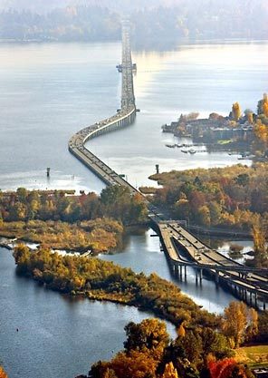
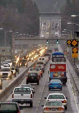


Unsound Transit
